
An upgrade of ECMWF’s Integrated Forecasting System (IFS) to Cycle 47r3 implemented on 12 October has improved the representation of moist physics in the model and increased satellite observation usage in cloudy regions in data assimilation.
The upgrade improves the large-scale atmospheric circulation and reduces tropical cyclone track errors in both high-resolution (HRES) and ensemble (ENS) forecasts.
It is the second upgrade this year, after May’s upgrade to Cycle 47r2, and comes before the transition to a new high-performance computing facility in ECMWF’s data centre in Bologna, Italy.
Changes in moist physics
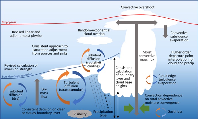
There has been a major revision to the representation of physical processes in IFS Cycle 47r3. The illustration below shows the scope of the changes.

This illustration highlights many of the turbulence, cloud and convection processes that have been modified in the moist physics upgrade in IFS Cycle 47r3.
Improvements have been made to the representation of turbulence, convection, saturation adjustment, and cloud and precipitation microphysics. The complicated interactions between these processes are also described more simply, efficiently, consistently and scale-independently.
The developments are a culmination of work spanning several years and are part of a long-term development of the moist physics in the IFS in preparation for the transition to higher horizontal resolutions (3–5 km) in future operations.
More details can be found in a recent Newsletter article.
Increased observation usage
The upgrade has continued our successful long-term strategy of exploiting satellite radiance observations not just in clear-sky but in all-sky conditions, in other words in clear, cloudy and rainy situations.
In particular, AMSU-A microwave temperature sounding observations – some of the most powerful observations assimilated into the IFS – have had their use expanded from clear-sky to all-sky conditions.
The increased data usage in cloudy regions leads to an improved fit to independent satellite and conventional observations, and an improvement in forecast scores.
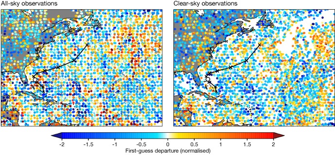
The filling of data gaps in cloudy regions is very clear in the case of tropical cyclone Humberto (see the illustration). Coverage is improved in the immediate vicinity of Humberto (indicated by the white circle), but also in the surrounding region, which is likely to be important for influencing its subsequent track (indicated by black crosses).

First guess departures for all-sky (left) and clear-sky (right) channel 5 observations assimilated during the 12-hour long window starting at 00 UTC on 15 September 2019. The National Hurricane Center (NHC) best track locations at 00 UTC over the life of Humberto are given by a black X, with a white circle showing the hurricane location at 00 UTC on 15 September 2019, just east of Florida. Data from all AMSU-A platforms are shown together. Departures are normalised by the assigned observation errors.
With Cycle 47r3, the only passive microwave instrument assimilated in just clear-sky conditions will be ATMS, which is expected to be moved to all-sky assimilation shortly.
Other examples of better observation usage include improvements in radiative transfer ‘RTTOV’ calculations for hyperspectral infrared sounders, and a reassignment of heights for some low-level Atmospheric Motion Vector (AMV) observations.
Improved forecasts
There are many positive impacts of Cycle 47r3, particularly on upper-air scores and tropical cyclone tracks.
Upper-air geopotential and wind in the first few days of the forecast are significantly improved, by up to a few per cent for the northern hemisphere 500 hPa geopotential anomaly correlation, reducing with lead time. Upper-air winds are particularly improved in the tropics throughout the medium range.
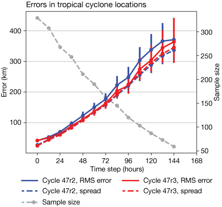
For tropical cyclones, there is a 10% improvement in the track location errors in both HRES and in the ensemble mean of ENS from forecast days 2 to 5. This is a result of the additional observations assimilated in cloudy regions and model changes which improve the steering flow.

The chart shows root-mean-square (RMS) location errors (solid lines) in the ensemble mean of tropical cyclone positions in Cycle 47r2 (blue) and 47r3 (red), along with the standard deviation (spread, dashed lines) among ensemble members. Results are based on all TC basins for the period from 2 December 2020 to 30 August 2021. The dashed grey line and the right-hand side scale indicate the number of tropical cyclones which could be evaluated at each lead time. The bars indicate 95% confidence intervals.
The impact of Cycle 47r3 on medium-range near-surface parameters is more mixed. Total precipitation is improved globally in the ENS. There is a small improvement in 2 m temperature in the extratropics, but a small degradation in the tropics. Two-metre dew point, 10 m wind and cloud cover also show small deteriorations. With such a major physics change, it is inevitable that there are some degradations, and these will be the focus of changes in later IFS cycles.
There are improvements to existing forecast products, such as visibility, wind gusts and ocean wave peak period, and several new products for CAPE (convective available potential energy), CIN (convective inhibition) and clear air turbulence.
Overall, the package of changes in Cycle 47r3 is an important step in the development of the IFS, improving performance overall, extending our use of existing observations, and providing a stronger foundation for further development of the model and data assimilation at current and higher resolutions.
“I am delighted to see the delivery of this Cycle, which brings forward developments originally planned for next year,” said ECMWF Director of Research Andy Brown. “It leads to an immediate improvement in many measures of forecast performance, and it paves the way for further developments."
“We have introduced several new products which were requested by users across our Member and Co-operating States in this upgrade,” ECMWF Director of Forecasts Florian Pappenberger added. “Working closely with the European Severe Storms Laboratory, a new improved CAPE output has been introduced. Responding to user feedback, we have also improved visibility and wind gust forecast products.”
More information
Further information, including interactive scorecards, is available from the Cycle 47r3 implementation web page.
