Sean Healy, ECMWF Senior Scientist and Team Leader, Earth System Assimilation Section, Research Department
I’ve been working on the use of Global Navigation Satellite Systems (GNSS) signals to improve numerical weather prediction (NWP) forecasts since 1996, but 2020 has been the most exciting year for some time.
You are probably most familiar with the Global Positioning System (GPS) as a tool for navigation. At ECMWF we use signals from GPS – and now other GNSS systems – to retrieve temperature and humidity profile information using a measurement technique called radio occultation.
Radio occultation (RO) has a rich history. It was pioneered in the 1960s by the planetary science community in the United States (US). In fact, in 1965 the Mariner-4 mission used RO to provide the first measurements of the atmosphere of Mars. A quick web search shows that it is still used today.
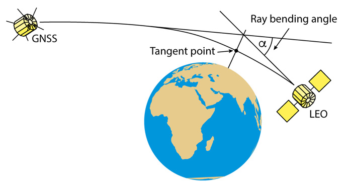
The GNSS radio occultation (GNSS-RO) observations we use at ECMWF use a satellite-to-satellite geometry (Figure 1). The concept was first discussed in the late 1980s in the US, and demonstrated in the 1990s with the GPS/MET mission. Essentially, we look at how the path of the GNSS signal between the satellites is bent by the atmosphere, and then we retrieve atmospheric state information from this bending. We’ve been assimilating GNSS-RO measurements at ECMWF since 2006.

Figure 1: A radio signal is emitted by the GNSS satellite and measured with a receiver placed on the low earth orbit (LEO). The path of the radio signal is bent as a result of refractive-index gradients in the atmosphere. The motion of the LEO satellite enables the variation of ray-bending with tangent height to be derived.
Although I think the value of GNSS-RO for NWP and climate reanalysis applications is now generally established, my view for some time is that the overall impact has been limited by the GNSS-RO data numbers. The three Metop satellites have provided the bulk of our data in recent years – around 1,800 RO profiles per day – and they have been absolutely crucial for ensuring the continuity of GNSS-RO in both NWP and reanalyses. However, in simulations we’ve shown that more GNSS-RO observations would be beneficial, and the target is currently 20,000 per day, well distributed in both space and time.
The joint US/Taiwanese FORMOSAT-7/COSMIC-2 (COSMIC-2 hereafter) mission was launched in 2019, providing an additional 4,000 RO profiles per day, in a latitude band between ± 40 degrees, from six satellites. The early results with this data were presented at the ROM-SAF IROWG workshop in September 2019. They looked very promising, and I came away from that meeting with the aim of starting assimilation experiments as soon as possible.
In operational NWP, we like to get new data as early as possible for technical testing, accepting that there may still be problems, and that the processing is likely to change and improve. Fortunately, colleagues at the University Corporation for Atmospheric Research (UCAR) understand this, and they started making test data available in October 2019. We were able to gradually build up long assimilation experiments, which eventually spanned from October 2019 to late March 2020.

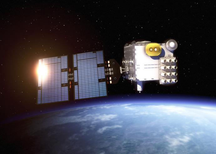
Figure 2: A FORMOSAT-7/COSMIC-2 satellite in orbit. (Courtesy Surrey Satellite Technology Limited)
The early period of testing new datasets always requires a lot of teamwork across ECMWF, because the data often arrives sporadically. In particular, I recall sitting in a near-empty building with Ioannis Mallas at about 16:00 on 23 December 2019, discussing how we could continue to acquire the data over the holidays, and keep the experiments running. I should add that Ben Ruston at NRL in the US had just announced the active assimilation of COSMIC-2 in their system (18 December 2019), using a near-real-time feed only available within the US, so the gold medal had gone!
During the early months of 2020 it was becoming increasingly apparent that the COSMIC-2 data were having a good impact in the assimilation experiments, and that we should start thinking about operational use. In the background, the COVID situation gradually was worsening, but to be honest I didn’t take much notice at the time.
By mid-March, the COSMIC-2 data were routinely available in near-real-time and we were convinced we could use them in operations. Then, of course, everything turned upside down. The Centre would be closed, and we’d start home working. I stayed working at the Centre as long as I could, finally leaving on 20 March. Given the context, I did wonder who really cared whether COSMIC-2 was operational or not, but – in what turned out to be one of our last ‘in person’ chats – Steve English talked about how we needed to keep things going during this difficult period.
We are now all used to making major operational changes from home, but it is a pretty remarkable achievement in my view, and it wouldn’t have happened 10 years ago. We started assimilating COSMIC-2 in operations during my first week of homeworking, on 25 March 2020. Sitting in a spare room, chatting to colleagues on Teams for probably the first time, was really odd, but it went surprisingly smoothly on the day.
The assimilation of COSMIC-2 was a key personal objective for the year, and it had been achieved in pretty good time. Nevertheless, when a new satellite system goes into operations there is always a nagging doubt – despite all the testing over many months – that something will “break”. You gradually relax as the days are ticked off after implementation. So, after a week or so, I could start to think more about other work.
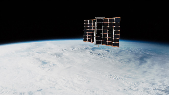
One of the COVID-related issues ECMWF was facing at the time was the significant loss of aircraft measurements. In recognition of these difficulties, Dr Peter Platzer – CEO of Spire – offered both ECMWF and the Met Office free access to the Spire near-real-time GNSS-RO data on 3 April 2020. The Spire satellites are small “cubesats”, and they can build about one per week, so they could become a major source of GNSS-RO measurements in the future. We had not looked at Spire data before. In fact, one of my post-COSMIC-2 jobs was preparing an ESA proposal to assess it. However, colleagues at EUMETSAT, NRL and the Met Office had investigated the data quality and the results were very promising. The Spire offer was time limited, and it was decided we would go for it.

FIGURE 3: The Spire Low Earth Multi-Use Receiver-2 (Lemur-2) satellite in space (Courtesy Spire).
Once again, I was discussing data acquisition with Ioannis Mallas, but now it was Easter and we were using Teams. He would work with Laurent Gougeon and Roberto Ribas to set up the new acquisition system, and liaise with Spire on issues related to it. Chris Burrows was loaned by the infrared radiance team to help run and analyse the experiments. Chris had previously worked on the assimilation of GNSS-RO at the Met Office. It was an intense period for all of us. The new near-real-time data acquisition system was set up quickly, and the experiments were started. We then established that our results were consistent with those of EUMETSAT, NRL and the Met Office, and the data went operational on 13 May 2020 – less than 6 weeks after the original offer. I thought we’d done well to get COSMIC-2 in so quickly, but the timescale for the Spire implementation was crazy!
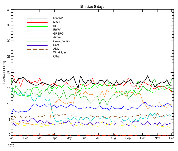
The overall impact of the GNSS-RO data in the ECMWF system increased during 2020 (Figure 4), and ultimately, we had access to the Spire data until 30 September 2020. The impact of the GNSS-RO in the stratosphere was already pretty well established, but the step forward this year has been the improvements in the troposphere. The COSMIC-2 data, in particular, provided the first clear impact of GNSS-RO on tropospheric humidity. This had been expected, but it had been difficult to demonstrate in NWP applications.
The second half of 2020 was a bit more relaxed, although an operational GNSS-RO failure in July (I should note – unrelated to either Spire or COSMIC-2) kept me on my toes.

Figure 4: The operational Forecast Sensitivity to Observation Impact (FSOI) timeseries. This is a globally integrated statistic summarising how the different observing systems contribute to the reduction of 24 hour forecast errors. The GNSS-RO (=GPSRO) contribution is the orange line. COSMIC-2 was assimilated on 25 March 2020 and Spire on 13 May 2020. Spire was assimilated until 30 September 2020.
Given the circumstances, the introduction of COSMIC-2 and Spire during the lockdown has been a significant achievement for 2020, but I want to emphasise that it relied on the skill, commitment and agility of many colleagues across ECMWF.
Banner image: Courtesy Surrey Satellite Technology Limited
