A daily clustering of the forecast fields from the ENS similar in principle to the old ENS clustering but using a different algorithm. The daily clustering determines weather scenarios, defined as the ensemble members closest to the centroid of each cluster.
A set of fixed climatological regimes for each season, computed using 29 years of reanalysis data (ERA-Interim and ERA-40).
This combined approach provides the user with:
a set of weather scenarios that appropriately represent the ensemble distribution
an additional objective measure of the differences between scenarios in terms of large scale flow (by using the attribution of each weather scenario to the climatological regimes)
easy computations of flow-dependent skill measures (under development)
Daily weather scenarios
The clustering is based on the 500 hPa geopotential forecast fields. The norm used is the root mean square difference. Clustering is performed over the following time windows: 3-4 days, 5-7 days, 8-10 days, 11-15 days. In order to preserve synoptic continuity the membership of each cluster remains constant for the defined time period (few days): for two ENS members to belong to the same cluster, they must display a similar synoptic evolution of 500 hPa geopotential over the chosen time window. For each time window an extended-in-time Empirical Orthogonal Function (EOF) decomposition of the ENS 500 hPa geopotential fields is carried out. The ENS clusters are computed in the phase-space spanned by the first N leading extended-EOFs whose cumulated variance explains at least 80% of the total ENS variance in the forecast range 5-7 days.
The set of ENS clusters is described by the cluster centroids. The ENS members closest to the cluster centroids (we refer to these as the "weather scenarios") are used to represent the ENS clusters. In order to identify the most representative ENS member, a pattern matching algorithm, based on the minimization of the distance using the root mean square metric, is used. Clustering is performed using the same K-means methodology as for the climatological clusters (see below). The number of clusters varies from case to case depending on the variation within the ENS For each case, partitions of the ENS into 2, 3, 4, 5 and 6 clusters are considered. A number of tests are used to define the best criteria to identify the optimal number of ENS clusters for each time window. When the ENS ensemble distribution is sufficiently homogeneous the clustering algorithm cannot partition the ensemble and therefore no significant clusters are detected.
Climatological regimes
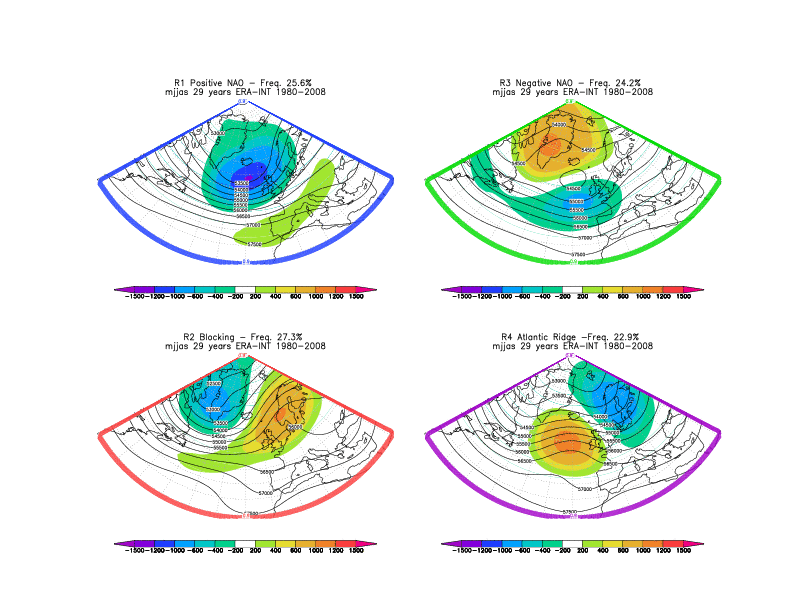
Climatological weather regimes are computed for cold (October to April) and warm (May to September) seasons, using 29 years of ERA-Interim and ERA-40 data. The clustering procedure includes low pass filtering of daily data, Empirical Orthogonal Function (EOF) decomposition, cluster definition, based on the modified K-means technique described in Straus et al. 2007, cluster significance testing and a pattern matching facility. Four patterns, consistent with those documented in the literature (see for example Michelangeli et al. 1995) are considered.
Figure 1 below shows the geographical patterns (both anomalies and full fields) associated with the cold season clusters. Cluster 2 represents Euro-Atlantic blocking, while clusters 1 and 3 reproduce the positive and negative phase of the North Atlantic Oscillation (NAO). Cluster 4 shows a pattern with a pronounced ridge over the Atlantic.
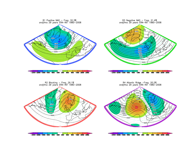
Figure 2 below shows the climatological regimes for the warm season. Each climatological regime is associated with a specific colour: Positive NAO pattern is associated with blue, negative NAO with green, Euro-Atlantic blocking red and the Atlantic ridge pattern with violet.
Attribution of ENS clusters to the climatological weather regimes
A pattern-matching algorithm is used to assign ENS weather scenario to the closest (in terms of the chosen metric) climatological weather regime. For each time window each of the weather scenarios are associated with a climatological large-scale atmospheric flow pattern. Graphically the attribution of daily scenario is represented by the colour of map frame. For example if one scenario has its frame coloured in red it signifies that its large-scale features resemble those represented by the Euro-Atlantic blocking.