
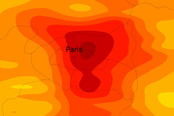
The urban environment will for the first time be considered in ECMWF’s Integrated Forecasting System (IFS) from next year. This is important because in cities temperatures are often elevated compared to their surroundings.
The atmospheric impact of urbanisation is multi-faceted. It includes direct contributions to an urban heat island (UHI) from anthropogenic heating and cooling. Buildings also change winds, and urban materials affect the thermal and hydrological properties of the surface.
The IFS will have a horizontal resolution of 9 km in ensemble forecasts from 27 June. This means that, with improvements in global satellite-based datasets, the main weather effects specific to urban areas can be represented.
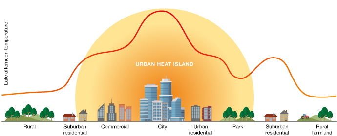
Urban areas heat up more than others mainly due to the thermal properties of the surface, with an additional contribution by anthropogenic heating and cooling.
Outline of the scheme
ECMWF has designed a simple scheme which considers cities as an interface between the sub-surface soil and the atmosphere.
This includes an additional urban tile, sub-divided into urban canyons with road bases and roof fractions bordering them on either side.
As detailed mapping of urban environments is not available at a global scale, several broad assumptions are made in the model. An example of this is an assumed universal average building height of eight metres and a fixed unitary building-to-road ratio.
“Overall, the scheme aims to improve the energy and moisture exchange between the surface and the atmosphere to better estimate near-surface weather conditions across all forecast times,” says ECMWF scientist Joe McNorton.
Performance of the scheme
ECMWF typically verifies near-surface model performance using 2 m temperatures and 10 m wind speeds measured by SYNOP weather stations.
When averaged over more than 6,000 sites, the urban scheme outperformed the control IFS model for both near-surface temperatures and wind speed at all forecast times. There was a model improvement of about 0.5% for temperature and about 0.8% for wind speed up to ten days ahead averaged across all sites, most of which are in rural environments.
“When we focus on 27 densely populated urban sites, the improvement further increases to about 10% for both summer and winter months,” Joe says. Temperature and wind speed error reductions at those sites can be seen in the figure.
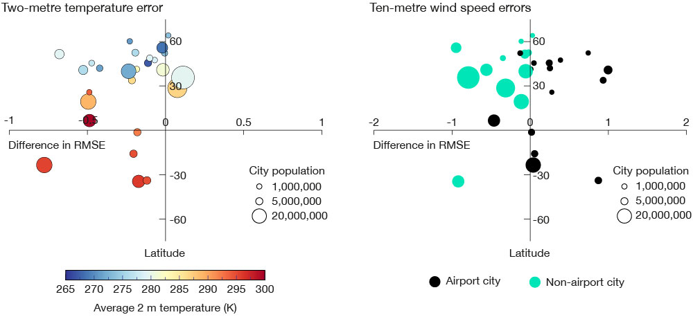
These plots show the average difference in root-mean-square error (RMSE), for various forecast times between 12 hours and 10 days, between the urban IFS and the operational IFS when compared with observed 2 m temperature (left) and 10 m wind (right) from 27 urban sites for northern hemisphere winter, 2018. Negative x-axis values indicate model improvement when using the urban scheme.
High-resolution application to Paris
Meanwhile, research is ongoing to include urban schemes in finer-resolution global models, such as those planned for the EU’s Destination Earth initiative.
As part of this work, ECMWF is contributing to the World Meteorological Organization’s Research Demonstration Project (RDP) for the Olympic Games in Paris in 2024. This project is looking into weather forecasts of very fine resolution in cities and urban areas.
The plots below show experimental 22-hour ECMWF temperature forecasts for Paris at a horizontal resolution of 4.4 km during a heatwave in June 2022 without the urban scheme (top) and with the urban scheme (bottom).
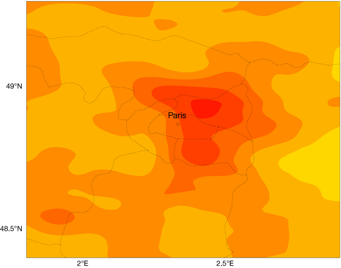
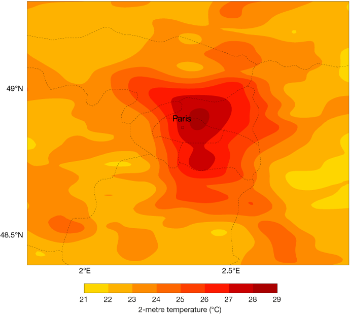
These plots show 22-hour experimental ECMWF forecasts of 2-metre temperature at a horizontal resolution of 4.4 km for 17 June 2022 at 22 UTC without the urban scheme (top) and with the urban scheme (bottom).
“It can be seen that, even without the urban scheme, temperatures are predicted to be slightly elevated in the Paris region due to a mix of initial conditions and the land conditions in the model,” says ECMWF scientist Birgit Sützl. “With the urban scheme, however, temperatures are predicted to be much more elevated because urban effects are taken into account.”
Since these forecasts use a resolution of 4.4 km across the globe, they cannot consider smaller-scale differences in the urban landscape, such as large parks. The RDP also includes models making predictions at 100 metres or less. An example is the Meso-NH model of the French research community.
A simulation of 2-metre air temperature at a horizontal resolution of 100 metres shows big differences between the centre of Paris, on the one hand, and the Bois de Boulogne and Bois de Vincennes at its western and eastern edges, on the other.
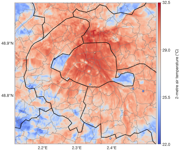
A 100-metre resolution 22-hour forecast of 2-metre air temperature in the Paris region for 17 June 2022, 22 UTC, using the Meso-NH model. The coloured circles indicate observed values. Source: CNRM
“The Research Demonstration Project is designed to improve day-to-day alerts but also to create knowledge on urban micro-climates in order to help cities mitigate heat impacts,” says Valéry Masson of the French Centre National de Recherches Météorologiques (CNRM), who coordinates the RDP.
Further reading
More information on the urban scheme to be introduced into the IFS next year can be found in this Newsletter article. For more information on the RDP for the Paris 2024 Olympics, see the CNRM website.
