
In the next upgrade of ECMWF’s Integrated Forecasting System (IFS), extended-range forecasts will have 101 instead of 51 ensemble members and will run more frequently than before, at a consistent horizontal resolution of 36 km.
The upgrade from IFS Cycle 47r3 to 48r1 is scheduled to take place on 27 June 2023. The changes lead to improvements in forecast performance across all parameters.
ECMWF’s extended-range forecasts provide predictions up to 46 days ahead.
More ensemble members
The 51‑member ensemble in the current configuration cannot always properly capture small shifts in forecast probabilities. This is true in particular when the signal is very small compared to the ensemble spread.
Doubling the ensemble size to 101 ensemble members will provide a more accurate representation of the forecast probability distribution function.
Below we show an example of the impact of increasing the ensemble size to 101 ensemble members for one of the extended-range forecast products: the probability of tropical cyclone tracks within 300 km over a weekly period, in this case week 4.
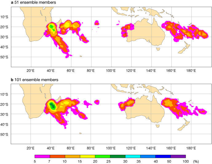
Tropical storm strike probability maps for week 4 for the extended-range forecast starting on 7 January 2021, showing (a) the strike probability produced with a 51-member ensemble and (b) the strike probability produced with a 101-member ensemble, both in the real-time forecast configuration.
The charts show that the areas of high probability of tropical cyclone tracks look broadly similar between the 51- and 101‑member ensembles, but there are significant differences.
For instance, the 101‑member ensemble forecast displays higher probabilities of a tropical cyclone strike over the Mozambique Channel and west and northeast of Australia than the 51-member ensemble. It also shows lower probabilities east of 180°E. In the event, tropical cyclones did strike in the first three locations and did not strike in the fourth.
Greater frequency
In Cycle 48r1, extended-range forecasts will run daily rather than twice-weekly. This increased frequency will significantly improve the quality of extended-range forecasts for days of the week other than Monday and Thursday.
The impact of the increased frequency can be seen in forecasts of the Madden–Julian Oscillation (MJO). The MJO is a travelling pattern of variability in the tropical atmosphere which can have strong impacts in the mid-latitudes. It is characterised by an eastward progression of large regions of enhanced and suppressed rainfall.
The figure below shows an example of the benefit of the increased frequency for the prediction of the MJO (see the blue line). It shows that, by running extended-range forecasts every day, the predictive skill of a forecast produced on Sunday is significantly higher than the predictive skill of a forecast which is three days old (current configuration).
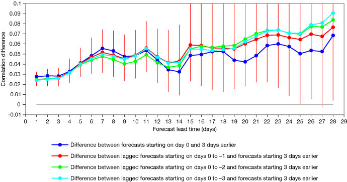
Difference of MJO bivariate correlation between 5-member ensemble re-forecasts starting on 1 November and 1 February 1989–2016 and re-forecasts starting 3 days earlier. Positive values indicate an improvement resulting from using forecasts without a 3-day delay. The vertical red lines indicate the 90% level of statistical significance. The red, green and cyan curves represent the difference when using a lagged ensemble with more members (respectively days 0 to –1; days 0 to –2 and days 0 to –3).
The daily frequency will also make it possible to create lagged ensembles, where the forecasts of previous days are combined with the most recent forecasts to produce a larger ensemble. This enables more skilful forecasts overall.
The figure shows an example of the benefit of a lagged ensemble for the extended-range prediction of the MJO. The benefit of the lagged ensemble (red, green and cyan curves) increases with lead time. It starts to be visible only after about 10 days of forecasts and becomes substantial in weeks 3 and 4.
Consistent resolution
In Cycle 48r1, the horizontal resolution will be kept at 36 km for all extended-range predictions. Currently it is 18 km up to day 15 and 36 km up to day 46.
The change was motivated by research experiments which did not show any statistically significant impacts resulting from the change in resolution.
For more information on the changes to extended-range forecasts in IFS Cycle 48r1, see this Newsletter article.