The global population reached eight billion in 2022, with about 55% residing in urban areas. The urban environment is not currently considered in ECMWF weather and seasonal predictions or in global reanalyses. A simple, yet effective, representation of sub-grid and resolved urban elements affecting local weather and climate is being implemented in the Integrated Forecasting System (IFS). The scheme will become operational in IFS Cycle 49r1 and future Copernicus reanalyses data products, such as ERA6.
In cities, temperatures are often elevated due to an effect known as the urban heat island (UHI). This further intensifies the impact of extreme heat events on the local population and ecosystems. The atmospheric impact of urbanization is multi-faceted and includes direct contributions to the UHI effect from anthropogenic heating and cooling. Buildings alter the surface morphology, whilst urban materials change the albedo, emissivity, and both thermal and hydrological properties of the surface. Other climatic impacts come from anthropogenic activities, including irrigation, drainage, snow-clearing and trace gas emissions. These components are known to impact, amongst other things, temperature, wind fields, surface heat and moisture fluxes, the boundary layer height and precipitation.
The urban scheme
Historically, cities have been difficult to resolve in global weather modelling, owing to the coarse spatial resolution of those models and the lack of reliable datasets to specify the spatial distribution of urban areas. With recent and foreseen improvements in the IFS resolution and global satellite-based datasets, the main weather effects specific to urban areas can now be represented. A simple scheme which considers cities as an interface between the sub-surface soil and the atmosphere has been designed and implemented. This includes an additional urban tile, sub-divided into urban canyons with road bases and roof fractions bordering them on either side. Overall, the scheme aims to improve the energy and moisture exchange between the surface and the atmosphere to better estimate near-surface weather conditions across all forecast times.
Local weather impact
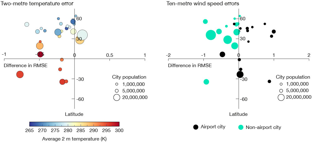
ECMWF typically verifies near-surface model performance using screen-level temperatures and 10 m wind speeds measured by SYNOP weather stations. When averaged over more than 6,000 sites, the urban scheme outperformed the control IFS model for both near-surface temperatures and wind speed at all forecast times. There was a model improvement of about 0.5% for temperature and about 0.8% for wind speed up to ten days ahead averaged across all sites, most of which are in rural environments. When we focus on 27 densely populated urban sites, the improvement further increases to about 10% for both summer and winter months (see the temperature and wind speed error figure). It is well known that the UHI effect is greatest at night-time, and the model reflects this.
As detailed mapping of urban environments is not available at a global scale, we make several broad assumptions in the model. An example of this is an assumed universal average building height of eight metres and a fixed unitary building-to-road ratio. The shortcomings of this approach are evident at sites that include airports, where the model over-estimates building fraction and, as a result, reduces wind speed too much (see the wind speed error graph). These assumptions can be relaxed in future work, when we plan to test more detailed mapping information that recently became available, such as spatially varying building heights.

Environmental impact
The introduction of an urban scheme is of particular interest also for monitoring greenhouse gas emissions. More specifically, ECMWF is helping to build a prototype system for a European Monitoring and Verification Support (MVS) capacity for anthropogenic CO2 emissions as part of the EU-funded CoCO2 project. Such a system relies on accurate high-resolution initial estimates of emissions. Currently the EU-funded Copernicus Atmosphere Monitoring Service (CAMS) implemented by ECMWF provides predicted atmospheric CO2 concentrations based on monthly maps of emissions from different sectors (energy production, manufacturing, settlements, and transport are among the four dominant sources). We utilise the urban map introduced combined with predicted temperature to estimate daily emissions of CO2 from residential heating in urban settings in real time. We validated our approach for Modelling Emissions from Heating in Near-real-time Driven by the IFS (MEHNDI system) against observed gas consumption from France and compared it with a state-of-the art emissions model, the TEMPO system, currently used in CAMS (see the second figure). We found that MEHNDI provides an accurate temporal and spatial variability of residential heating emissions, which can be used to accurately report emissions as required by the European MVS system.

Atmospheric concentrations of CO2 from IFS simulations driven by both MEHNDI and CAMS emissions were evaluated with total column CO2 observations from the global Total Column Carbon Observing Network. We found that, over or near urban sites, MEHNDI improved model performance and therefore it is scheduled for implementation in CAMS. This work highlights the benefits of an improved surface representation for weather and environmental applications. Future research is planned on other trace gases and aerosols as well as on the simulation of anthropogenic heat sources.
Further details are described in the recent publications McNorton et al., 2021, https://doi.org/10.1029/2020MS002375, and 2023, https://doi.org/10.1029/2022MS003286.
The CoCO2 project (grant agreement No. 958927) is funded by the European Union. Views and opinions expressed are, however, those of the authors only and do not necessarily reflect those of the European Union or the Commission. Neither the European Union nor the granting authority can be held responsible for them.
